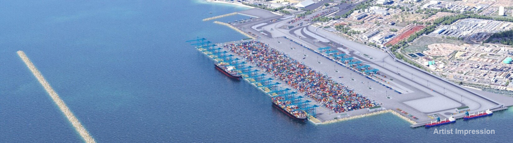
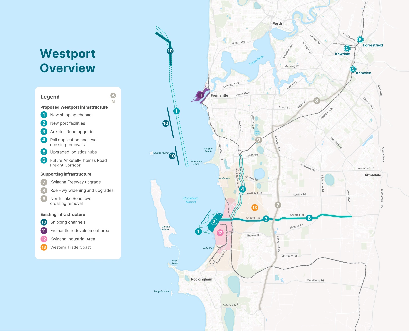
We have identified the preferred design for Western Australia’s future container port and supply chain. It includes a new port terminal in the Kwinana Industrial Area and marine infrastructure in Cockburn Sound, supported by an upgraded road and rail freight network and logistics hub.
The preferred design will provide a modern and efficient port and freight network to future proof trade in Western Australia, enhancing Kwinana’s status as a world-class industrial hub, and minimising environmental impacts to support the long-term health of Cockburn Sound.
What’s included in Westport's preferred design?
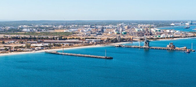
- A new port in Kwinana between the end of Barter Road and the end of Mason Road.
- A new freight corridor along Anketell Road and Thomas Road.
- Road upgrades along Anketell Road, Kwinana Freeway, and Roe Highway. Ultimately, the Anketell-Thomas Road Freight Corridor will connect the port with Tonkin Highway in Byford.
- Upgrades to the existing freight rail network between Kwinana and Cockburn, connecting the port with a logistic hub in Kenwick, Kewdale, and Forrestfield.
- A new shipping channel to accommodate larger ships expected in the future.
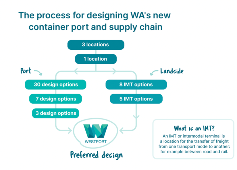
The process for identifying the best design for the port
Between 2018 and 2020, the previous ‘Westport Taskforce’ looked at 25 different locations between Fremantle, Cockburn Sound and Bunbury for the new container port. This led to the Kwinana Industrial Area as the best location for a new port, serviced by an upgraded Anketell Road.
In 2021, after undertaking a range of additional studies on operational and sustainability needs, Westport identified a long-list of seven port design options. This long-list was narrowed to a short-list of three options using a multi-criteria analysis (MCA) process.
The MCA considered environmental impacts, long-term sustainability, efficiency of the supply chain and port, and financial value. Assessment criteria used in the MCA were based on Westport’s goals and subgoals, with scoring criteria and measures.
As part of the evaluation process, Westport also held a series of specialist stakeholder workshops, who helped to identify gaps in the assessment criteria, evaluate the goal weightings, and provide general feedback.
The preferred design was the best choice for protecting the environment and avoiding disruption to important services in the area. While some other options had small advantages in certain areas, these came with bigger environmental impacts that made them less suitable overall.
The process for determining the landside design
In 2022, through the Landside Logistics Opportunities Study, Westport identified three network options for the freight and logistics network. The options included a combination of existing and new intermodal terminals (IMTs) to be established, as required by growing demand. In total, eight IMT options were identified across the three network options.
Through the MCA process and targeted stakeholder engagement these options were further tested and refined to reach a preferred option for the supply chain, including road and rail corridors, and intermodal terminals.
Taking into consideration the forecast traffic growth, the preferred design proposes
upgrades to Anketell Road, Kwinana Freeway, and Roe Highway. This will be followed
by the full development of the Anketell Thomas Corridor to follow.
In order to ensure a high rail share for containers, the preferred design includes rail
duplication and level crossing removals between the port terminal and
Cockburn Triangle.
Westport's Business Case design
Watch the flythrough of Westport's Business Case design (2023).
A design shaped by science and people
Westport engaged extensively with industry including leading experts in engineering, marine science, sustainability, and transport, to develop and review the design options.
We’ve had significant face-to-face technical engagement with industries and organisations that will operate within the port and supply chain. This level of engagement in a pre-business case project is unusual, but important when designing something to be operated by multiple interfacing private operators across the supply chain.
Community and Aboriginal groups were extensively consulted, through more than 600 community interviews to map the important places and features around Cockburn Sound that the community enjoy, analysis of community infrastructure and priorities with Local Governments, the recording of recreational fishing locations with fishers, and innovative mapping of Noongar cultural and spiritual locations and Songlines.
Examples of transport and trade modelling inputs that helped develop, evaluate, and refine preferred design included:
- Calculations regarding capacity of the container terminal and intermodal terminals.
- Simulation of container movements and mode choice across road and rail networks.
- Simulation of private and non-container traffic.
- Calculations of emissions across the network.
- Analysis of key performance metrics, with a particular focus on the cost per twenty-foot equivalent units (TEU) for container movements across the supply chain.
- Scenario analysis of trade impacts due to changes in supply chain capacity and efficiency.
- Analysing and determining economic drivers of container trade such as population growth, income levels, consumption, and exchange rates.
Examples of marine and terrestrial investigations that helped develop, evaluate, and refine preferred design included:
- Benthic habitat mapping of Cockburn Sound and Owen Anchorage.
- Hydrodynamic modelling based on oceanographic data.
- Geophysical and sediment surveys within Cockburn Sound.
- Landside geotechnical site investigations between the port and Rockingham Road, as well as Anketell and Thomas Roads.
- Marine geotechnical investigations in Cockburn Sound and up through Gage Roads to the Open Water Channel.
- Environmental, ground, and utility surveys west of Rockingham Road and the Anketell Road corridor.
Learn more about Westport's marine research.
Examples of port operations modelling inputs that helped develop, evaluate, and refine preferred design included:
- Simulation of vessel movements through the channel and into the port, under different conditions such as storms and engine failure.
- Forecasting the number of containers and ships that will arrive in Western Australia over the next 50 years.
- Wave modelling data and downtime analysis.
- Under keel modelling.