Seagrass in WA
Growing in ‘meadows’, seagrass is critical to the underwater ecosystem, providing habitat for fish, improving water quality and storing carbon.
Seagrass habitats can be found all along the coast of WA, with significant seagrass communities in Shark Bay, Cockburn Sound, Geographe Bay, and the South Coast.
The seagrass habitat of Cockburn Sound experienced significant losses from the 1950s to the 1990s due to a notable increase in nutrients and pollutants from industrial activities in and around Kwinana. Since then, there have been concerted and widespread efforts to improve water quality in Cockburn Sound, and active restoration of seagrass habitat.
Westport and seagrass
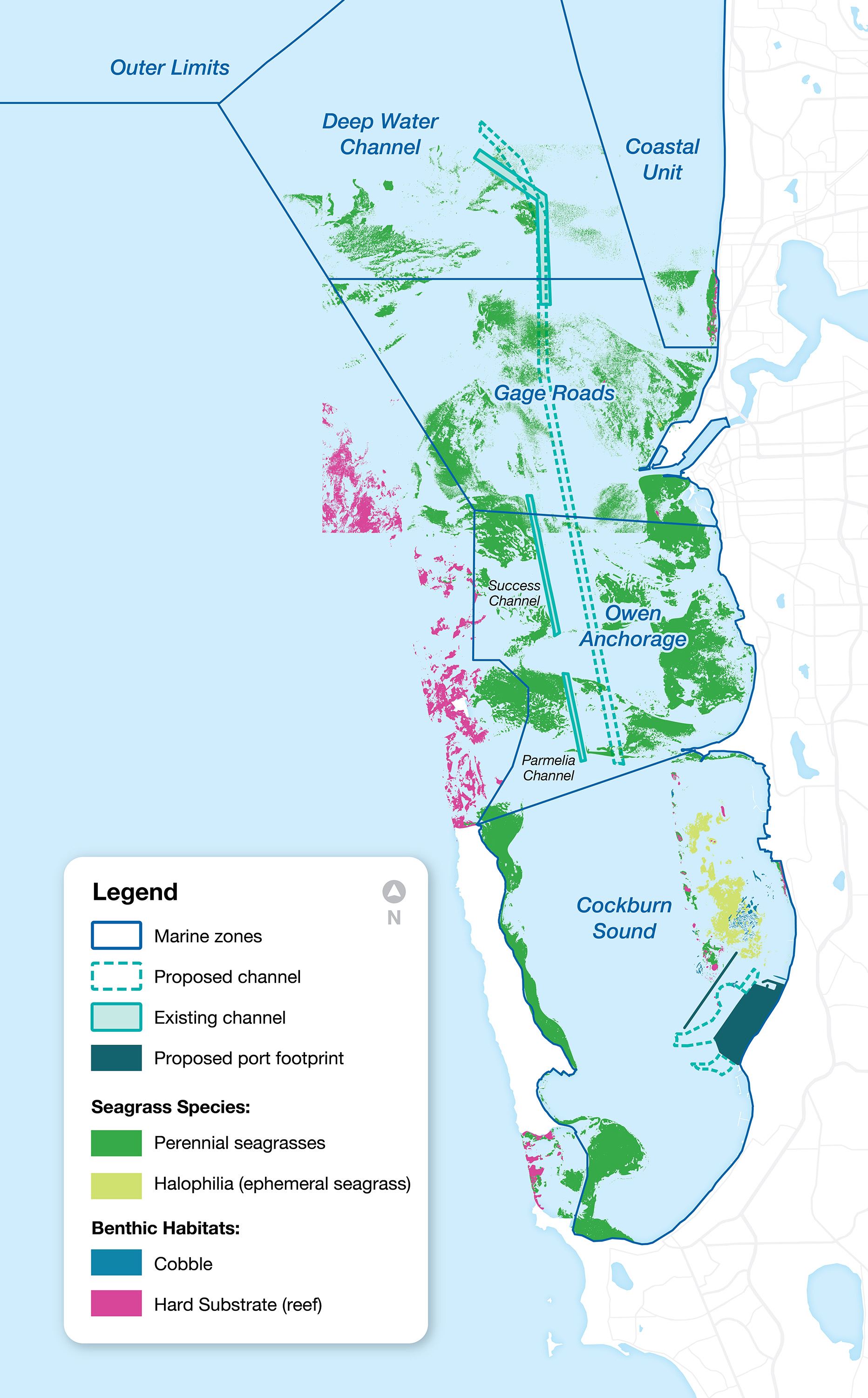
Westport’s proposed design for the new port and marine infrastructure at Kwinana covers four different marine zones including Cockburn Sound, Owen Anchorage, Gage Roads, and the Deep Water Channel near Fremantle, with areas of seagrass in all four zones.
As part of the WAMSI-Westport Marine Science Program, more than 4,000 hectares of seagrass has been mapped across four marine zones – Cockburn Sound, Owen Anchorage, Gage Roads and the northern Deep Water Channel.
Westport has actively worked to avoid direct and indirect impacts to seagrass from the marine infrastructure.
These strategies include:
- Avoiding direct impacts to seagrass habitat where possible through the port design process. Following mapping, the location of the port footprint was shifted one kilometre to the south of its original location to avoid directly impacting (i.e. removing) key seagrass meadows in Cockburn Sound.
- Based on the current design, we anticipate the new channel and port footprint will directly impact (i.e. permanently remove) approximately two percent of existing seagrass across three zones – Owen Anchorage, Gage Roads and the Deep Water Channel. Westport’s ongoing design refinement will continue to look to avoid and minimise seagrass impacts to the greatest extent possible.
- Minimising and managing indirect impacts to seagrass during port development. These kinds of impacts can occur through sediment burial or light quality during activities like dredging. Planning for dredge management will include water quality monitoring during dredging to maintain conditions for healthy seagrass.
- Restoring seagrass before and after development to support habitats. This activity will aim to significantly increase overall seagrass habitat in Cockburn Sound, both before and after the port’s development.
Further seagrass research
As well as mapping seagrass meadows along the WA coast, the WAMSI-Westport Marine Science Program has undertaken a number of other seagrass related studies that has given us the best understanding of seagrass habitat in Cockburn Sound that we’ve ever had.
Research projects on seagrass include new research on light and sediment tolerance thresholds and requirements for successful seagrass restoration will help increase effectiveness of future seagrass restoration activities.
This research will support Westport’s dredge management planning, and its commitment to significantly scaling up seagrass restoration programs in Cockburn Sound.
The seagrass research will inform Westport’s environmental impact assessment’s that are currently underway with both the State and Federal environmental regulators on the proposed marine infrastructure, which the EPA will release for public comment in 2026.
Seagrass restoration
Westport is committed to significantly scaling up seagrass restoration in Cockburn Sound before and after the port development.
Westport has begun this process by bringing together seagrass experts, key restoration programs, technology, and the WAMSI seagrass research, to put WA at the forefront of global seagrass restoration efforts.
OzFish’s community-led Seeds for Snapper program, the largest seagrass restoration program in Australia, has been provided with $500,000 in funding to support the program’s expansion as it works to restore Posidonia australis meadows in Cockburn Sound and Owen Anchorage.
Westport has also funded a $230,000 Australia-first trial of pioneering robotic seagrass planting technology developed by Ulysses Ecosystem Engineering, which was trialled in the November 2024 planting season in Cockburn Sound.
The seagrass planting robot injects the seeds directly into the sediment, improving the rate of planting and likely germination of the seeds, as compared to the current manual methods of dispersal. More will be known about the success of the trial in March 2025.